
A blog post from Colin: Now that our RV travels are over, several of our friends (particularly those not enamored of Facebook) have asked if I would publish some of my photographic efforts on this website.
 This will be the first post, showing photographs taken on a 5 day photography workshop I attended in the Outer Banks, North Carolina with 8 other attendees. It was run by David Blecman of Positive Negatives.from 11th to 15th September 2021.
Fishing Piers and Beach
An early morning session at Nags Head beach proved very productive as the light went from blue to orange from pre-dawn to sunrise. Then, later in the week, we visited Avon Pier for some more pier scenes, including some long exposure shots.
Click on any thumbnail below to see larger size image gallery.


Lighthouses
A photographic trip to the Outer Banks wouldn’t be complete without some lighthouse pictures.
We had some discussion about the ethics of using the latest ‘sky replacement’ software to enhance pictures taken on e.g. cloudless days. So I included an example below.
Click on any thumbnail below to see larger size image gallery.


Wildlife
My favorite photographic genre.
Click on any thumbnail below to see larger size image gallery.


Landscapes, Sand Dunes …
Click on any thumbnail below to see larger size image gallery.


Nags Head, NC


 Our wonderful dog Bindi did not do well on our journey to Cape Breton and back. Every time the RV was moving, she was panting, shaking and pacing, these symptoms worsening the longer we drove. We now see that the accident we experienced in the Spring of 2019 had affected her ability to travel comfortably. While Cheryl recovered physically and we both regained our enthusiasm for long distance travel, Bindi’s symptoms did not improve. We tried many things to help resolve the problem, including prescribed medication, a device that helped patients with PTSD control their symptoms, and homeopathic remedies. Colin even built a new seat between the front two that raised her to our level and took her to the park in the van most days so that she could get used to it again. It seemed like she was improving. We planned a day trip to Assateague National Seashore to see how she would deal with a longer journey (3 hours each way). Sadly her symptoms remained, worsening as we drove. She had a great time running on the beach and we thought that being tired out would help her settle on our drive home. This was not to be. Her symptoms worsened on the journey back to Annapolis and she was in a sad state by the time we reached home, recovering quickly as soon as the RV stopped moving.
 This left us in a predicament. Our travel plans were all geared around long trips, stopping off to visit friends on the way. Florida, Arizona, Colorado, California, and Oregon. This would mean leaving Bindi at home for many weeks, either with friends or with a pet sitting service. We reached the conclusion that this was not an option. We thought about keeping the RV through the end of the year to make some short trips, particularly as traveling in a self sufficient RV like ours is probably the safest way to travel at the moment. Eventually, in mid-June, we decided to put the RV on the market for sale, motivated in part by the very high demand for vehicles like ours during the pandemic. Within two weeks, we had an offer at the listed price and the sale was completed over the weekend. We said goodbye to our house on wheels, on Tuesday.
We don’t yet know what new adventures might be in our future. Travel plans are impossible at the moment. Colin is continuing with his photography exploits and we both enjoy our musical efforts. Cheryl is swimming three times a week and Colin is hiking local parks about 4 miles a day with Bindi so we are not ‘throwing in the towel’ to old age yet. This website might morph into a photographic site without the travel emphasis.
We’ll keep you posted…
Thanks to our friends for supporting our site with your wonderful comments…
Colin and Cheryl, 9th July 2020

We were hoping that by pushing our return date back to mid-October, we would see some Fall colors. We were not disappointed, particularly driving the Kankamagus trail through the White Mountains of New Hampshire and the Green Mountains of Vermont. This will be the last post for this trip, we’re looking forward to re-acquainting ourselves with our home in Annapolis.
Click on any thumbnail below to see larger size image gallery.


-

- Ski slopes in background


We had originally planned two months in Nova Scotia when we left in June. However, this being our second attempt, leaving late August, we knew that if weather and health held up and we were able to make it that far North, time would be short and we would need to focus on one area. By the end of September, the weather looked possible so we decided to push North through New Brunswick into Nova Scotia arriving 30th September. We decided to focus our time for the next two weeks on Cape Breton, an island North-East of the mainland.

Replica of Scottish Croft in memory of the Highland Clearances
The island was one of the main areas where Scottish farmers landed during the Highland Clearances (1750-1860) having been forced out of the Highlands of Scotland. Of course the immigrants brought with them Gaelic/Celtic culture, particularly dance and fiddle music. The combination of isolation and poverty kept the music traditions intact and Cape Breton traditional fiddle music is now well known throughout the world. With our interest in Celtic music, Cape Breton seemed the best place to spend our limited time.
We stopped the first night night in the middle of the Nova Scotia mainland. I think we misjudged the size of the island, as it’s about 350 miles long, about half the area of England. Cheryl was disappointed to find that Nova Scotia Lox was not in abundance due to the historic lows of Wild Atlantic Salmon population. Lobsters, however were plentiful as in Maine.

Canadian Coastguard waiting to transit lock at Canso Causeway
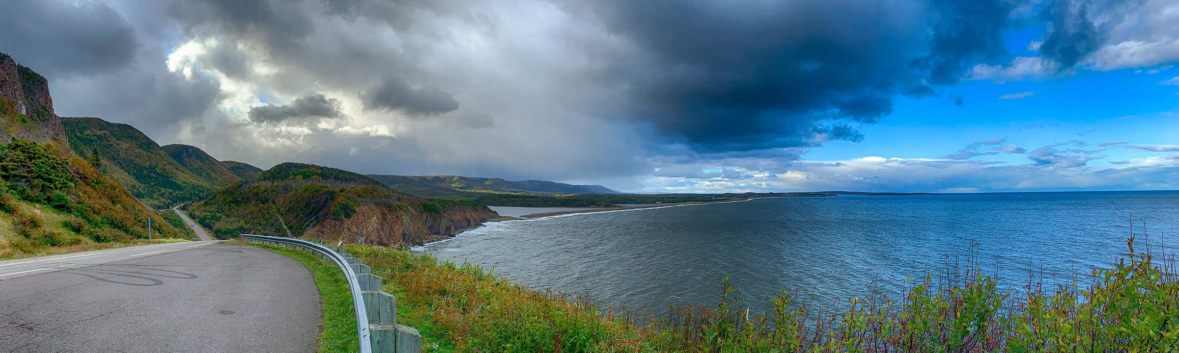
We crossed the Canso Causeway (completed in 1955 to link Cape Breton to the Nova Scotia mainland) the next day and followed the ‘Ceilidh Trail’ up the West Coast where we had booked several nights in the Cape Breton Highlands National Park. The first two nights were at Cheticamp campground on the West Coast, where we found some local (but not traditional) music in a pub. Colin and Bindi enjoyed the Salmon Ponds trail and the Acadian trail which followed the upward course of a stream (multiple waterfalls) and then magnificent views over the ocean. Our third night was at the Ingonish campground on the East Coast. This is a truly beautiful part of the world, reminiscent of the Western Isles of Scotland. We drove the ‘Cabot Trail’ along the Northern coastline and enjoyed some great coastal scenery.

‘The Red Shoe’ at Mabou, known for hosting traditional music
For the second week we focussed more on finding traditional music. We returned to the West Coast and spent time in Baddeck, Judique and Mabou where we were entertained by several different traditional local musicians (particularly Mike Hall and Chrissy Crowley), even recognized some of the tunes as ones in our own repertoire. Baddeck is situated beautifully on the Bras d’Or Lake (saline, so also known as an inland sea) where we visited the Alexander Graham Bell Museum. We learned about the contrast in styles between Bell and Edison who worked together on the development of the telephone. Bell spent a good part of his life on his estate near Baddeck.
Click on any thumbnail below to see larger size image gallery.
-

- Canadian Coastguard waiting to transit lock at Canso Causeway


-

- Nova Scotia Fixer-Upper


-

- Salmon Ponds trail


-

- Acadian trail


-

- ‘Not another waterfall’


-

- Canadian Park sign…

-

- … and a chair to enjoy the view


-

- Broad Cove nr. Ingonish


-

- Cabot Trail…


-

- Scottish Crofter Hut replica


-

- Cabot Memorial


-

- Church now a Culture Center


-

- Baddeck

-

- Alexander Graham Bell Museum

-

- Mike Hall at Baddeck

-

- Bras d’Or Lake at Baddeck


-

- Mabou Pub

-

- Chrissy Crowley playing at the Red Shoe

-

- Mabou Views…


Mike Hall playing in Baddeck, Cape Breton
Chrissy Crowley playing in The Red Shoe, Mabou, Cape Breton
Map Text
Click on map to show location detail

Fundy National Park
 We crossed the border into New Brunswick, Canada without incident and headed for Fundy National Park where we were booked in for three nights at the Point Wolfe campground. Looking at the van’s GPS on the way to the campground, we were surprised to see we were on Micmac Road! It turns out that there is a local tribe of ‘First Nation’ people with the name Mi’kmaq. Our van’s license plate ‘Mick Mac’ was of course not named after them but after Colin’s father, Mick McNaught, who’s students shortened it to MickMac.
The campground was accessed via a covered bridge (rare in this part of the world) so was restricted to vehicles similar or less in length to ours. The park covers a large part of the New Brunswick coastline of the Bay of Fundy. This has one of the highest tidal ranges (close to 40 feet) and also has a tidal bore like the Severn River Estuary between England and Wales. The first evening, Colin and Bindi hiked down to the beach and discovered (it was low tide) they had another rocky mile to walk to get to the ocean!

Low Tide at Wolfe Pointe
 New Brunswick and Nova Scotia have many place names in common with Scotland and England. Even so it was a surprise to find our milk cartons with the name ‘Northumberland’. (Colin was born in Northumberland, which borders Scotland, and plays a type of bellows-based bagpipe called, the Northumbrian Smallpipes).
The three days were spent mainly hiking some of the trails near the campground. One of these led to Dickson Falls which gave Colin many opportunities take on of his favorite types of landscape subjects. We also explored the fishing village of Alma, on the edge of the park. The high tidal range also presents a challenge to the fishing fleet which is only able to enter and leave the harbor a short period before and after high tide.
Click on any thumbnail below to see larger size image gallery.
-

- Entering New Brunswick

-

- Cheryl at the Helm

-

- Micmac Everywhere!


-

- Covered bridge in Fundy NP


-

- Unique cabin in Fundy NP called Ôasis

-

- Sunrise at Wolfe Pointe


-

- Low tide from the covered bridge…

-

- …High Tide


-

- Lobsterman at Work

-

- Dickson Falls

-

- Dickson Falls

-

- Dickson Falls

-

- Dickson Falls

-

- Northumberland Milk

-

- Hurricane Dorian Impact


-

- Low Tide at Alma

-

- High Tide at Alma


-

- Sunset on Alma beach

Click on map to show location detail
Hopewell Rocks
This national park, further North on the shore of the Bay of Fundy, is unique in what it calls, “Flower Pots,” the shape of the rocks after eons of the weathering effect of the high tides.  There’s such a big difference between high and low tides, as illustrated in this ad for the rocks we found on the Internet. The upper half of the picture shows high tide and kayakers, the bottom half shows low tide with people walking on the sea bed floor. Bindi and Colin made the trek to the rocks and Bindi had a terrific time playing in the mud while Colin took some photographs.
  Meanwhile, Cheryl maintained a lookout in the park’s cafe. Note that even in New Brunswick, Kashi products were available (with French subtitles)! Some of you know the story, but for those who don’t: Cheryl’s brother Phil and wife Gayle (P&G) created the Kashi company in La Jolla, CA in 1981. After a successful 19 years, the company was sold to Kelloggs and since then, P&G travel the world and do philanthropic work. For more info: Kashi
Click on any thumbnail below to see larger size image gallery.
-

- Low Tide at Hopewell Rocks


-

- Flowerpots at Hopewell


-

- Bullwinkle and Bindi

Click on map to show location detail

Blackwoods Campground

Downtown Bar Harbor
Located at the Southern tip of the Eastern part of Acadia NP, Blackwoods Campground is a beautiful wooded area with a short trail to an ocean overlook. It is accessible to free bus routes covering the main section of the park which we took advantage of a couple of times (dogs travel free, too). We loved the town of Bar Harbor, in spite of the thousands of dispatched tourists/passengers from the massive cruise ships, clogging up the town! The locals get the benefit of the income, but boy oh boy are the streets crowded – more by foot traffic from the ship passengers. That’s why the car traffic was less than expected based on the amount of visitors. And this was after the summer holidays when the children were back in school. But the town has a high cute factor and the amount of restaurants and gift shops outdistances any town we’ve seen before. The town grid is only about 20 x 20 streets, so it’s very compact. Cheryl’s favorite store was one suggested by Laura and Bill Michaud (see previous post) called, Bark Harbor. It was a dog-centric store but had a few other animal gifts as well. Yep, we dropped a few dollars there, for sure.

Bindi and Harvey at Sand Beach
Colin and Bindi had excursions into the wilds, hikes that were challenges, especially Cadillac Mountain Ridge Trail which started in the campground and led up the park’s tallest mountain. The hiking maps stated that the path was dog friendly, and it was, until a 6′ high vertical boulder appeared with a steel rung sunk into it. This was to help hikers up the boulder; Colin had a reluctant Bindi at first, but convinced her to ascend eventually. Descending was more of a challenge…
A lovely surprise was getting together with an English couple, Steve and Kathryn Goodenough (yes, it’s their real name!) and dog Harvey. They have been in the U.S. for quite a few years and currently live in Annapolis where we met them through mutual friends (thank you Heinz and Verena Thoma). We had a spectacular time together, enjoying hiking (Colin and Steve + 2 dogs on the Ocean Path to Otter Point and back to Great Head via Sand Beach) and relaxing/shopping (Cheryl and Kathy). Poor Kathy had recently had a foot injury so was a perfect companion to the careful-walking wounded Cheryl. The Goodenough’s purchased a van similar to ours but made by Winnebago, so we had a lot in common.
Click on any thumbnail below to see larger size image gallery.
-

- Downtown Bar Harbor

-

- Bar Harbor Schooner vs. Cruise Ship

-

- CJ’s ice cream shop; same initials as Colin’s

-

- Ocean View near the campsite


-

- Coming Dad?


-

- Note rung in rock shadow

-

- Cairns on the way up Cadillac Mountain

-

- View from the top


-

- A Spent Bindi

-

- Surf’s Up


-

- Bindi and Bindi

-

- A Sleeping Princess


-

- Lobster boat


-

- Bindi and Harvey


-

- Photographing Colin Photographing


-

- The Goodenough’s van

-

- Anti-mosquito patches


-

- A Hint of Fall


-

- Sun Battling the Fogbank

-

- Misty Morning

Click on map to show location detail

Acadia National Park consists of several separate areas, most of which are located on Mount Desert Island. The Island is split by Somes Sound running North to South, separating the Western half of the Island from the Eastern half which contains the more well known tourist areas of the park plus the town of Bar Harbor. Our first week was spent based at the Seawall Campground. 
Seawall Campground
Located near Southwest Harbor, on Western Mount Desert Island, Seawall Campground is one of the two Acadia National Park campgrounds allowing RVs like ours to stay. It’s named after the natural wall of rocks washed up by ocean surf over time. (By the way, a ‘beach’ in Maine is a collection of rocks no smaller than a fist.) It provided us great wooded settings about a 10 minute walk from the ocean ‘seawall’. Acadia NP has many many hiking trails of varying difficulty, most involving a lot of climbing. A large proportion of them are open to dogs as well, so Colin and Bindi went on many, many hikes, climbing a lot of the peaks in the Western part of the island. Cheryl joined them on a short hike along the Ship Harbor trail, otherwise spent most of her days reading and practicing her concertina.
Click on any thumbnail below to see larger size image gallery.
-

- Moonrise

-

- Bindi spots a Chipmunk

-

- Chipmunk Teases Bindi

-

- Chipmunk Talking

-

- Schooner leaving Bar Harbor

-

- A trail rest


-

- Sunrise at the Seawall

-

- Waiting for picnicers


-

- “Come on Dad!”

-

- Colin hikes to Mr. Sauveor


-

- Government Survey Point 1940

-

- Harvest Moon Rising


-

- Beetle on Flower


-

- Bindi and Cola Bear

-

- View from Beech Mountain


-

- Season vs. Time

-

- Sunrise at Seawall

Click on map to show location detail

Friends on ‘Lake Lucerne’
 We had planned this part of the journey, but it was still a surprise. We had known Bill and Laura Michaud from our Sopha Medical days, when Colin was President and CEO, based in Columbia, Maryland. The company sold cameras and developed software for the Nuclear Medicine medical equipment market. Cheryl, too, worked for the company, as she held technical degrees in Nuclear Medicine, Radiology, and MRI.

Sopha Medical Gamma Camera
Bill was the Eastern Regional Sales Manager during that time and when he won top Salesman of the Year awards, twice, we got to go on a vacation with Bill and Laura. The President’s Club Award consisted of a cruise to the Caribbean one year, and a trip to Paris for a week in France the following year. Getting together after 20+ years was just too long a break. Although we had exchanged Christmas letters every year, we missed their bright conversations, their shared love of all things dog, and their optimism. The Michaud’s property sits on a lake (known locally as ‘Lake Lucerne’ after the Inn situated at its edge) and has every toy and convenience possible.

Bill and Laura
Their amenities and generous hospitality were top-notch, and they spoiled us rotten for the 3 days we stayed with them including giving Colin a complete tour of the lake by boat in search of Loons. We loved hearing the eerie call of the loons through the mist early in the morning.

Lola and Brooke
They even listened to us (and filmed us) playing duets for them. Bill and Laura are now retired, and along with their dogs Lola and Brooke, they have a great life-style they have been able to afford through hard work and excellent work ethics. Two of the most lovely people, two of the most sweet dogs.
Click on any thumbnail below to see larger size image gallery.
-

- Bill Michaud and Colin

-

- The house that Bill and Laura built

-

- The Michaud Property


-

- The Michaud Property


-

- View from the water


-

- Loons: Lucerne Neighbors


-

- House for sale?


-

- The Michaud property from the water


Click on map to show location detail
Camden Hills State Park
Located a few minutes north of Camden, the park offers year-round trail activities and camping. This park is renowned for the panoramic view of Camden Harbor and Penobscot Bay from the top of Mt. Battie, which inspired Colin and Bindi to hiked the afternoon we arrived. There was an annex to the park across the main road accessing the ocean front which was a great area for early morning hikes.
Click on any thumbnail below to see larger size image gallery.
-

- Bindi, trailblazing

-

- View from the top

-

- Camden


-

- Salmon steaks on the grill

-

- Colin going through his photographs

-

- RVs big…

-

- …and small

-

- Ocean view from the park’s annex


Click on map to show location detail

Boothbay Harbor

Sunset at Boothbay Harbor
It was a lovely surprise to become friends with Nancy and Fred Kelly. Fred is famous around the Chesapeake Bay because of his many, many years of service as an environmental attorney and the helmsman behind the Severn Riverkeeper Association organization, now their Executive Director. Nancy too has a background in environmental science as she was the first staff biologist for the Chesapeake Bay Foundation, and then began her own environmental consulting firm; they make a great team. A few years ago, the Kelly’s asked our advice and inquired about our Sprints-Based RV, and since then, we’ve become friends. The Kelly’s have since moved from the Annapolis area and commute (via their own RV) between Boothbay Harbor and Savanah, GA where their daughter and family live. We were lucky enough to meet up with them in Boothbay Harbor where Nancy gave a tour of her hometown, where she grew up, and the environmental station where her father worked. Fred, in the meantime, took Colin on a powerboat tour of several lighthouses and talked about the boating in the waters around Boothbay Harbor. Besides being such gracious hosts, meals together, and sharing stories (oh, so many stories), we also played music together. Nancy plays the harp and so we temporarily switched from a duo to a trio. Great fun.
Click on any thumbnail below to see larger size image gallery.
-

- Fred and Nancy Kelly

-

- Sunset at Boothbay Harbor

-

- Burnt Island Light

-

- Burnt Island

-

- Cuckolds Light

-

- Ram Island Light

-

- Ram Island Light


-

- Where Nancy grew up, next door, original home is gone

-

- Kelly’s Community Marina

Click on map to show location detail
Camden
We stopped at Camden on our way North. We hadn’t ever seen such a concentration of Schooners offering tours. The town was picturesque and the harbor busy and beautiful. We also drove through Belfast which had some very extensive boat-building and service operations.
Click on any thumbnail below to see larger size image gallery.


-

- Town Center Waterfall Preservation seems to be a big issue

-

- $40 for something washed up on the shore?


-

- Belfast, Maine

-

- Belfast Harbor

Click on map to show location detail


The Barn
We’ve known about Owls Head, Maine, because of our previous next door neighbor in our community in Annapolis. Susan and Norm Thomas spoke about it often and with such love, that we knew we had to experience it for ourselves. The Thomas’ moved away from Annapolis about 10 years ago to return to Susan’s hometown and build their dream home. The live-in ‘barn’ was constructed first, and when they moved into it, they were able to start the build on the main home. They love their town and both are extremely active on multiple boards, especially the Farnsworth Museum where Susan gave us a personal tour of the artwork. There’s quite a few Wyeth paintings, and three of the many family artists were well represented.
The nearby and larger town of Rockland has much to offer in the spirit of New England fare. We enjoyed visiting the lighthouses, restaurants, and viewing the restoration and revitalization of the town.
On the way to our next destination, we visited Marshall Point and enjoyed the beautiful weather and scenery.
Click on any thumbnail below to see larger size image gallery.
-

- The Thomas’ Home

-

- The ‘Barn’


-

- 1 of 3 Thomas Kitties

-

- Rockland Harbor

-

- Rockland Breakwater Light taken from the Thomas home

-

- Farnsworth: Lobster Art (Xray claw beneath)


-

- Farnsworth: Children’s Art


-

- Owls Head Lighthouse


-

- Lobsterman Art

-

- Local lobster fishing


-

- Owls Head Post Office


-

- Rockland

-

- Rockport Harbor


-

- Rockland Breakwater


-

- Owls Head State Park

-

- Can I come too?


-

- Marshall Point Lighthouse


-

- Fisherman’s Memorial

Norm Thomas is on the board of the Transportation Museum located in Owls Head and suggested that we visit. This museum housed a treasure trove of objects which represented mechanical greatness of the 1900s. Intricate and capable, these machines were a marvel, especially to an engineering geek who loves to view intricate workmanship (read, “Colin”). For such a small town, this was an amazing variety of art in the form of transportation.
Some pictures from the Owls Head Transportation Museum
Click on any thumbnail below to see larger size image gallery.


Map Text
Click on map to show location detail